
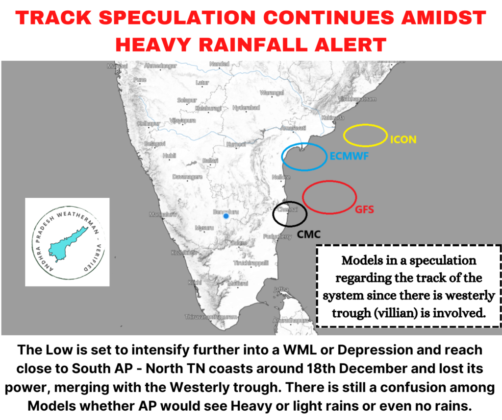
Fresh Low Pressure over South Bay of Bengal will track towards West-North-Westerly direction and move slowly in North-Westerly direction from today evening onwards. This would probably bring system close to us by 18th late-night or 19th early-morning. However, rains still remain doubtful since there is a high speculation in the tracks due to westerly trough influence. As of now there are few things that are confirmed.
- Light Rains are confirmed for entire Coastal Andhra Pradesh starting from Srikakulam to Tirupati. Complete 900 kms coastline on December 18th.
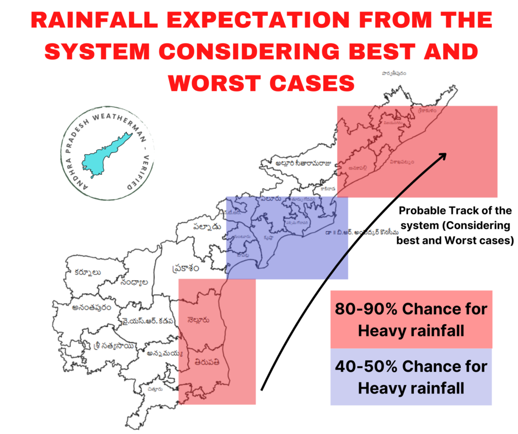
- From December 19th, Extremely Heavy rainfall alert is 50-50 for Coastal Andhra Pradesh belt since there are confusion in the tracks. If system moves a bit closer towards our coast, then rains the regions that would get impact will be Visakhapatnam – Anakapalli belt, Tirupati – Nellore belts and also Konaseema – West Godavari – Diviseema belts due to its geographical locations. However I am not going to confirm.
- The pull of system’s north-west winds will cause colder early mornings in Rayalaseema and Telangana belt with temperatures going as low as 8 C or 9 C especially Kurnool – Anantapur belts closer to Karnataka.
- If system completely misses, the system would loose track in Bay of Bengal and all the remnants of the system would probably drift towards South Coastal AP and adjoining North Tamil Nadu causing rains during last week of December due to dry-wet interaction.
My views on the system track (Personal views) and its influence on Andhra Pradesh
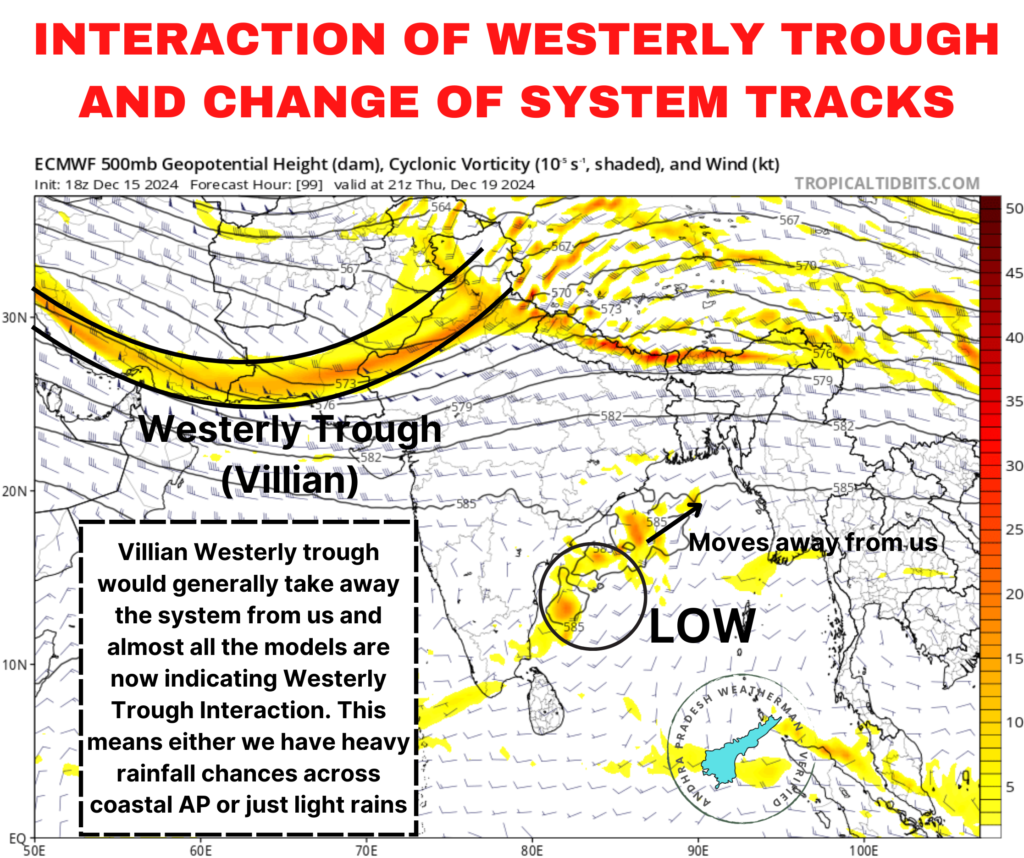
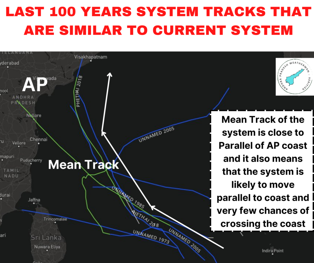
I have done some in depth analysis of the system track and its likelihood to impact on our state. I have identified that almost all the tracks of Cyclones or Depressions went parallel to Andhra Pradesh to coast with few systems like Phetai (2018) cross us but ending up in giving Heavy rainfall along coast. The system would behave in a very similar way but the rains would be confined to coastal belt particularly the geographical extended regions of Visakhapatnam – Anakapalli, Konaseema – Diviseema and also Tirupati – Nellore belts since they are extended a bit into sea, they have high chances for getting the rains from this system. Due to Westerly Trough Interaction the heavier rains or extreme rains would be more confined to open seas but for land, it would be lesser impact.
I have identified the areas where there are probabilities for Heavy rains. So it would be easy for everyone to understand.
Telugu translation for easy understanding
బంగాళాఖాతంలో ఏర్పడ్డ అల్పపీడనం తుఫాన్ గా ఏర్పడే అవకాశాలు లేవు కానీ వాయుగుండం వరకు వెళ్లే అవకాశాలు కనిపిస్తున్నాయి. ప్రస్తుతం ఉత్తర భారత దేశం నుంచి వస్తున్న పశ్చిమ గాలులు వాయుగుండాన్ని రాష్ట్రం నుంచి దూరంగా దారి మళ్లించే పని చేస్తూ ఉంది. దాని వలన కోస్తాంధ్రలో అతిభారీ వర్షాలకు 50% మాత్రమే ఛాన్స్ ప్రస్తుతానికి కనిపిస్తోంది. ప్రస్తుతానికి అన్ని మాడల్స్ తేలికపాటి వర్షాలకు అవకాశాలను చూపిస్తున్నాయి. ఈ వాయుగుండం సముద్రంలోనే బలహీనపడే సూచనలు ఉంది కాబట్టి డిసెంబర్ చివ్వరి వారంలో నెల్లూరు – తిరుపతి – ఉత్తర తమిళనాదూ ప్రాంతాల్లో వర్షాలను చూడగలము. ఇప్పుడు మిస్ అయినా, చివ్వరికి కొన్ని వర్షాలు మన వైపుగా రానుంది. కానీ అతిభారీ వర్షాలు ఒక వేళ పడితే విశాఖ – అనకాపల్లి, తిరుపతి – నెల్లూరు, కొనసీమ – పశ్చిమ గోదావరి – దివిసీమ ప్రాంతాలను ప్రభావితం చేస్తుంది. లేదంటే ఏమి ఉండదు, కేవలం తేలికపాటిగానే ఉంటుంది. డిసెంబర్ 18న కొన్ని తేలికపాటి వర్షాలను చూడగలము. ఆ పై ఎంత భారీగా ఉంటుందో అంచానా లేదు.